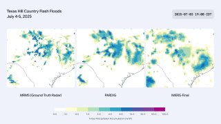
Precipitation data constructed with artificial intelligence.
PARDIG (Precipitation Reanalysis AI: Densely Inferred GPM) is precipitation data produced by an AI model trained on NASA Global Precipitation Measurement (GPM) satellite data. The input uses SatWeave imagery and ECMWF atmospheric fields. The result is global precipitation maps with a temporal resolution of 15 minutes and a spatial resolution of about 10 kilometers, updated with an average delay of about five hours.
According to Google, in light to moderate precipitation, PARDIG improves the quality of hourly precipitation detection compared to IMERG-Final GPM by more than 30%. This has been particularly effective in identifying extreme precipitation events that are difficult to identify with existing global products.
PARDIG data is publicly available on Google Cloud Storage and Google Earth Engine.
PARDIG is available in two versions:
PARDIG-NRT (Near Real Time) - 2016 - Present. V.
PARDIG-LR (long-term observations) - 1999–2023.
Hourly precipitation data from the July 2025 Texas Hill State floods: comparison of NOAA MRMS ground radar data (left, ca. 1 km) with near-real-time PARDIG data (center, ca. 10 km) and the GPM IMERG-Final source (right, ca. 10 km).