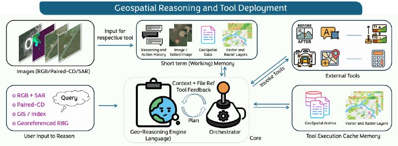
OpenEarthAgent is a unified platform for creating geospatial agents, complemented by a set of tools and able to formulate intelligible multi-step reasoning based on satellite images and GIS data. The system, developed for remote sensing missions, combines multi-spectral analysis, geospatial operations and natural language understanding technologies. The accompanying data includes 14,538 training samples and 169 evaluation samples. Training sample contains more than 100 thousand steps of thinking, test - more than 7 thousand. OpenEarthAgent can be used in urban environmental analysis, environmental monitoring, disaster response and infrastructure assessment. The platform supports GIS operations (for example, calculation of acreage statistics) with the calculation of various indicators, such as NDVI, NBR and NDBI. Open EarthAgent: A Unified Framework for Tool-Augmented Geospatial Agents.
OpenEarthAgent is a unified platform for creating geospatial agents, complemented by a set of tools and able to formulate intelligible multi-step reasoning based on satellite images and GIS data. The system, developed for remote sensing missions, combines multi-spectral analysis, geospatial operations and natural language understanding technologies. The accompanying data includes 14,538 training samples and 169 evaluation samples. Training sample contains more than 100 thousand steps of thinking, test - more than 7 thousand. OpenEarthAgent can be used in urban environmental analysis, environmental monitoring, disaster response and infrastructure assessment. The platform supports GIS operations (for example, calculation of acreage statistics) with the calculation of various indicators, such as NDVI, NBR and NDBI. Open EarthAgent: A Unified Framework for Tool-Augmented Geospatial Agents.
More on Radar
Want to see every report in real time?
Hundreds of sources worldwide, translated into your language, with alerts for what matters to you.
Sign up free Already have an account? Log in