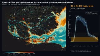
"Memory calculation of the concentration of suspended cements from Landsat and Sentinel-2 images based on the TripleS software complex" - November 11 at the conference at the Institute of Space Research "Excluded problems of the dispersion of the earth from space" will be presented the result of our many years of work on the development of a methodology for water tracking, mapping and ground archiving using compressed data. This work began 10 years ago, when the possibility of using satellite images to calculate the disturbances of water was first tested for Salanga. Furthermore, this technique was applied to the Upper Angra, Lena, Kolyma, Ob. Now the transition to the software implementation of this technique has occurred - the triple software complex (three S: Surface Suspended Sediment) has been created. The program code is open in the Google Earth Engine environment: (Authors of the methodology: Dr. S.R. Chalov; P. Golovlev, A.I. Innokentyev). An alternative web application is now complete based on the OpenEO and C libraries. Anyone can use the developed module. The created plan is: • to select dozens of scenes for a given area by dates, months and clouds; • Calculation of water shock fields with pixel averaging and reclassification at convenient intervals for hydrological interpretation; • To create not one "momentary" maps of shocks, but fields of average shocks of water for different states of water throughout all the available archives; Restore lines of each virtual point of a virtual stream of a virtual stream of a virtual stream of water, such as such, but from a subject. A detailed description of the tripleS software complex and its application is given in an accepted article in the journal "Excluded Problems of Remote Sensing of the Earth from Space". She sees the limitations of applying the technique to image resolution, the accuracy of methods and the relationships between disturbances and image parameters.
"Memory calculation of the concentration of suspended cements from Landsat and Sentinel-2 images based on the TripleS software complex" - November 11 at the conference at the Institute of Space Research "Excluded problems of the dispersion of the earth from space" will be presented the result of our many years of work on the development of a methodology for water tracking, mapping and ground archiving using compressed data. This work began 10 years ago, when the possibility of using satellite images to calculate the disturbances of water was first tested for Salanga. Furthermore, this technique was applied to the Upper Angra, Lena, Kolyma, Ob. Now the transition to the software implementation of this technique has occurred - the triple software complex (three S: Surface Suspended Sediment) has been created. The program code is open in the Google Earth Engine environment: (Authors of the methodology: Dr. S.R. Chalov; P. Golovlev, A.I. Innokentyev). An alternative web application is now complete based on the OpenEO and C libraries. Anyone can use the developed module. The created plan is: • to select dozens of scenes for a given area by dates, months and clouds; • Calculation of water shock fields with pixel averaging and reclassification at convenient intervals for hydrological interpretation; • To create not one "momentary" maps of shocks, but fields of average shocks of water for different states of water throughout all the available archives; Restore lines of each virtual point of a virtual stream of a virtual stream of a virtual stream of water, such as such, but from a subject. A detailed description of the tripleS software complex and its application is given in an accepted article in the journal "Excluded Problems of Remote Sensing of the Earth from Space". She sees the limitations of applying the technique to image resolution, the accuracy of methods and the relationships between disturbances and image parameters.
More on Radar
Want to see every report in real time?
Hundreds of sources worldwide, translated into your language, with alerts for what matters to you.
Sign up free Already have an account? Log in