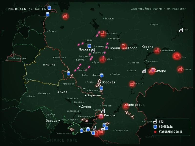
Map of unmanned and missile activity in Russia between 00:18-00:48.
Missile danger (pink arrows):
Bryansk and Pochep (Bryansk region), then Kaluga and Smolensk regions, using cruise missiles (00:33–00:40).
Oryol region, then Tula (00:39–00:41).
Moscow and the Moscow region from Tula and Kaluga regions: alarm for Flamingo missiles, two units (00:42–00:46).
Ryazan, Vladimir, Ivanovo, Yaroslav and Tver regions: danger from "Flamingo" (00:45).
Main directions of UAVs:
Border corridor: Bryansk region (Baklan, Pochep), Liptsk region from the intersection of Belgorod and Voronezh regions, Voronezh region along the same route.
South: Krasnodar region (Taman Peninsula, Anapa, Crimea region, Belya Galina), Zaporozhye region (Primorsk, Bardyansk, towards the Azov Sea), Crimea (Saki, Novopedrovka), south of the Volgograd region and north of the Kalmykia Sea towards the Caspian Sea.
Refineries and oil storage facilities are shown on the map. Those attacked since October 30 are marked in red.
The number of arrows (as an anti-aircraft missile) is conditional, the direction of the missile arrows is conditional.