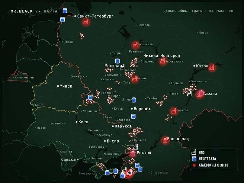
The map of unmanned activity in Russia from 23:20 to 00:17.
Main directions:
Moscow Region, East: Vaskarsansk, Kolomna, Shatura, Ramenskoye, Pavlovsky Posad, Orehovo-Zovo, Yegorievsk. Some of the UAVs move from Stura to the Vladimir region, some others fly along the border of the Smolensk and Moscow regions.
Bryansk, Oryol, Kaluga and Tula regions: Fukino, Blia Brega, Zurinich, Zmiivka. The main route through Bryansk, Ural and Kaluga.
South: Kerch Strait, Crimean Bridge, Bagrovo, Taman Peninsula, Anapa, Novorossiysk, Black Sea region and Azov region of Krasnodar Territory. Missile danger, two cruise missiles came from the Zaporozhye region to the south, additional missiles were detected from Berdyansk across the Azov Sea to the bridge, rocket targets came from the Zaporozhye region towards the Crimean bridge. From Armiansk, jet drones fly towards Simferopol, danger in western and central Crimea and Sevastopol.
Departure from the normal flight path:
Ulyanovsk region (Pavlovsky district, from Penza region, "many"), Samara, Saratov and Penza regions.
Novgorod region in the northwest.
Staroblask and further east, Chertkovsky district. Anthracite, Rubenki.
Refineries and oil storage facilities are shown on the map. Those attacked since October 30 are marked in red.
The number of shooters (as anti-aircraft guns) is conditional.