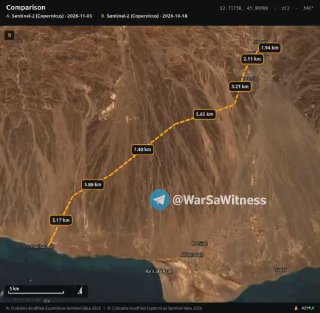
🛰🇾🇪. A comparison of Sentinel-2 satellite images from the Copernicus program, taken between October 18 and November 5, 2026, reveals the construction of interconnected fortifications and defensive earthworks spanning more than 30 kilometers in the southern part of the Lahige River.
🛰🇾🇪. A comparison of Sentinel-2 satellite images from the Copernicus program, taken between October 18 and November 5, 2026, reveals the construction of interconnected fortifications and defensive earthworks spanning more than 30 kilometers in the southern part of the Lahige River.
More on Radar
Want to see every report in real time?
Hundreds of sources worldwide, translated into your language, with alerts for what matters to you.
Sign up free Already have an account? Log in